THE ORIGIN OF THE NORFOLK BROADS
A CLASSIC CASE OF CONFIRMATION BIAS
BILL SAUNDERS
The Origin of the Norfolk Broads - a classic case of Confirmation Bias
mallards
The making of South Walsham Broad
The records of the manor of South Walsham Hall which have survived from the thirteenth and fourteenth centuries are cited by Smith as evidence of a great, dry pit becoming progressively flooded, with the disastrous storm and tidal surge of December 1287 deemed to be a major contributing factor.
There are three principal aspects to the evidence: firstly, records showing a fall in the manor's production of turf for sale in the second half of the thirteenth century, secondly, a valuation in 1315 of the manor's demesne turbaries, and, thirdly, some fourteenth century references to the presence of open water in these turbaries.
THE FALL IN SALES
"The earliest figures for the production of turf on a much larger scale come from South Walsham." Smith, 1960
Date Revenue Unit Sales Price per 1000
1268-69 £8 6s. 8d. 250,000 8d.
1269-70 £7 1s. 1d. 216,000 8d.
1270-71 £9 11s. 6d. 255,300 9d.
1276-77 £7 0s.10d. 169,000 9d.
1277-78 £6 14s. 0d. 161,000 10d.
1281-82 £6 5s. 71/2d. 167,000 10d.
1283-84 £4 1s 11/2d. 108,200 9d.
1284-85 £5 0s.101/2d. 134,500 8d.
1290-91 £2 2s. 7d. 56,700 8d.
1292-93 £3 18s. 6d. c.118,000 8d.
1296-97 £1 14s. 8d. - (52,000)* - (8d.)*
[Source: Smith,1960]
*My figures, but the only sensible ones compatible with the revenue of £1 14s 8d..
Smith comments as follows:
"Sales of turf were regularly much greater than and usually more than twice as valuable as the sales of stock, and at times were as valuable as sales of grain. They were more valuable than the rents drawn from pasture and herbage. Production of turf declined slightly from the peak of 1270 to 1284 but by 1290 there had been a considerable fall and the high levels of twenty years before were never regained. Other facets of the manorial economy suffered no comparable trends. The rents of pasture and the sales of stock were never so great as they were in 1296. It seems as though turf was becoming more difficult to extract in the last decade of the century. This decline in the productivity of the South Walsham turbaries continued into the 14th century."
"The 1287 flood coincides with a marked fall in the productivity of the South Walsham turbaries between 1285 and 1290."
"The end of the thirteenth and early fourteenth centuries witnessed decline in the production of turf at South Walsham, and this may be correlated with the results of the floods of 1287."
Here are exactly the same sales statistics in the form a graph:
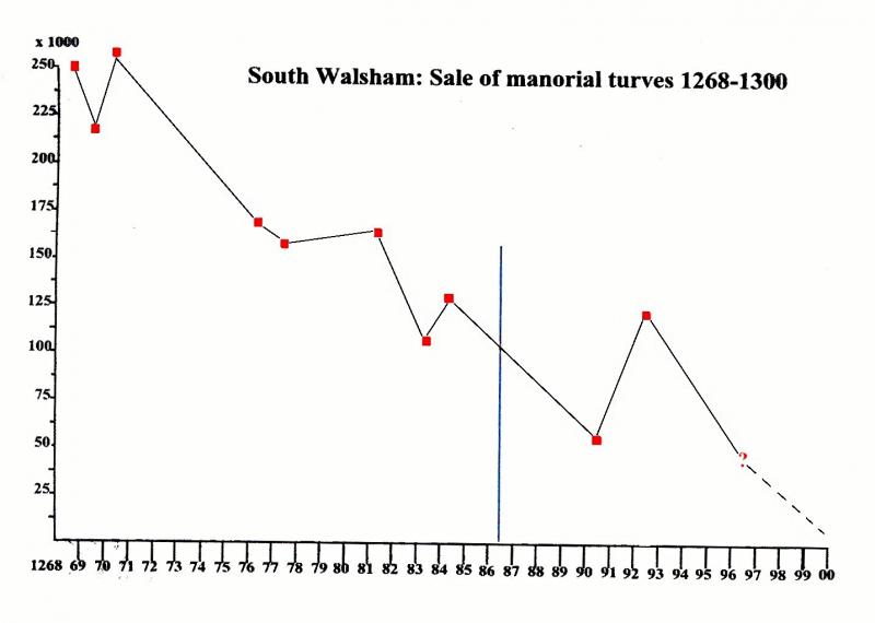
Is there any discernible difference between what Smith perceives as a "slight" decline between 1270 and 1284 and the "considerable fall" of 1284-1290 or the "marked fall" of 1285-1290?
How may a "decline in the production of turf at South Walsham [which clearly started in 1270] . . be correlated with the results of the floods in 1287"? The effect of a flood is unlikely to be retrospective. What is clear, however, is that the effects of this one were not only catastrophic, but also unprecedented.
"John of Oxenides, a monk of St.Benet's, wrote of it. In the month of December, the sea, agitated by the violence of the wind, burst through its accustomed limits occupying towns fields and other places adjacent to the coast, and inundated parts which no accounts in past times had recorded to have been covered in sea water [my italics] . . . At St.Benet's Abbey, all the outbuildings on lower sites were inundated by sea-flood to such a depth that they could be reached by boat." ibid.
Only half a mile away, the fen and turbaries at South Walsham must inevitably have been submerged beneath several feet of water.
- A catastrophe is by definition, however, an exceptional event; its effects are usually temporary.
Severe tidal surges in Broadland cause death and destruction, but within weeks the waters disappear from the fen surface and recede to their customary levels; the most enduring effect is the contamination of a fresh water environment by salt, but even this eventually dissipates.
- Reeds were cut in the middle of winter, not turf.
- If it was possible to bail out a peat pit, then it would still be possible once conditions in the fens reverted to normal after a flood.
It would, of course, have been possible to dig more small, separate sections.
Smith concluded from other evidence (see under "The making of Ormesby Broad") that, when a 'great pit' started to flood, conventional turf cutting became impossible, and that different, more time-consuming methods of turf production had to be introduced, which were up to twice as costly. Why then is this not reflected in post-1287 prices at South Walsham? If this sea flood had a permanent effect on production, how is it that more turves were sold in 1292-93 than in 1283-84?
At South Walsham there is a long, fairly constant decline in the sale of turves, the practice apparently ending after 1297; the documentary, physical and cartographical evidence, described by Lambert, Jennings and Smith himself, shows that they were running out of peat in the demesne turbaries (see below).
- There is no evidence that this decline was caused by the progressive flooding of a great pit which had formerly been free of water.
- There is no evidence that the effects of the 1287 sea flood on this or any other turbary were, or even would have been, anything but temporary.
A DECLINE IN VALUE
"In this [1315] extent, turbary worth 20s. a year is reported at Harefen, Northfen, Aglarwefen and Wodefen . . . .." Smith, 1960
"The extent of 1315 gives values for pasture and herbage which are quite comparable with those of thirteenth century account rolls. The valuation of the arable at £7 10s. 0d. is not inconsistent with the value of grain production, but the turbary was then worth only 20s. a year". ibid.
" . . . . the first suggestion of a broad comes in 1315 by which time the turbaries had declined in value from their heyday in the third quarter of the thirteenth century." ibid.
While no valuation figure for these turbaries seems to have survived from the thirteenth century, Smith must be right to assume that it would have been a great deal higher than it was in 1315. He sought to associate this decline with progressive flooding, leading perhaps to the presence of an actual broad. He clearly attached great significance to this interpretation, since the final summary of his conclusions in 1960 is partly based on it.
" . . . yet many pieces of evidence fit together to confirm strongly the thesis that the basins of the broads were literally dug out by hand, and that some of them at least were becoming flooded and increasingly worthless as turbaries and more valuable as fisheries from approximately 1300-1350." ibid.
There seems to be a fundamental misconception here.
If you dig up peat from a turbary to the maximum practicable depth, you create a hole in the ground which no longer contains any peat. That hole is ipso facto worthless as turbary. It makes no difference whether the hole then contains water or whether it contains air; it is worthless as turbary because it no longer contains any peat.
Common sense dictates that the value of a turbary, like the value of a mine, a quarry or an oil well, relates to the reserves which it contains. The presence of water in exhausted areas does not affect the value of the remaining reserves. It makes no difference whether you estimate that value by its capital worth or by its potential for annual rental. Nobody would pay rent for a piece of turbary which consisted of a hole in the ground with no peat in it.
Any active turbary will reduce in value. In contrast, given a reasonable standard of husbandry, agricultural land will maintain its productive value in perpetuity.
To compare the diminishing value of an active turbary with the constant value of pasture, herbage and arable land, and to take that as evidence of a formerly dry peat pit becoming flooded, is to twist the facts beyond breaking point in an attempt to make them fit Lambert's theory.
- It is not the increasing presence of water which causes a turbary to diminish in value, it the increasing absence of peat.
14TH CENTURY EVIDENCE OF OPEN WATER
"Among the valuations [in 1315] of mowing meadow, pasture and herbage, there was mention of 'several pasture at Harefen, Broddinge and under the wood of the Countess and it is worth 3 shillings a year'. It seems as though at least part of South Walsham Broad was in existence then. An isolated account roll for 1399 shows that turf is no longer sold (nor is turbary rented out), though among the pastures and herbage rented out there is mention of 6 acres of marsh with reed-bed (arundina), turf and and pannage, but is was worth only 3s. 1d.. By 1399 a fishery in Harefen was worth 5s., and there were 'flasshes to the north of Eastcroft. It is hard to resist the conclusion that by then South Walsham Broad was in existence.
A few of the St. Benet's account rolls of the late fourteenth century suggest a preoccupation with flooding. In 1379 18d. were spent on the drainage of the doles of workers digging peats at South Walsham; although reeds were a normal source of income it is stressed in one year that 'nothing was made from the marsh of South Walsham because the marsh was flooded, so the growing reed could not be cut'". ibid.
There is conclusive evidence that exhausted areas of turbary contained water in the fourteenth century. However, as with similar "transition" evidence, and especially in view of the dearth of comparable records from earlier centuries, it is in no way suggestive of the absence of water in the twelfth or thirteenth centuries. Smith simply makes that assumption.
Is a record of flooded reed beds in a single, late fourteenth century winter really suggestive of a "preoccupation with flooding"?
Since it would have been imposible to drain a pit by gravity, the 18d. spent in 1379 presumably paid for a channel to be dug to drain standing water from the surface of the doles. In adducing evidence to suggest abnormally wet conditions, Smith overlooks the reference to "workers digging peats".
- Here is direct documentary evidence of the conventional cutting of turves taking place in 1379 in one part of the South Walsham turbary, while ". . at least part of South Walsham Broad was in existence" elsewhere.
This and the references to six or more separate areas of demesne turbary, to the "flasshes", and to a fishery in Harefen are all strongly suggestive of multi-sectional excavation, rather than a single great pit, as indeed is Smith's own speculation that only part of South Walsham Broad was in existence in 1315. Turves were dug in one part of the turbary while other, exhausted parts were full of water, an imposssible combination in Smith's philosophy.
- The concept of the subsequent flooding of a great pit collapses.
ALL OF THE EVIDENCE
In the thirteenth and early fourteenth centuries, the market for peat was expanding, revenue and profit virtually guaranteed. Why then would South Walsham Hall have relinquished its share of this market, and with it what had clearly been a major source of income, unless it had been compelled to do so by deteriorating conditions in its turbaries, just as Smith concluded?
Take all of the available evidence, much of it provided by Smith himself, and the answer to that question becomes clear.
In the period when everybody thought the Norfolk Broads to be natural lakes, J.W.Gregory ("The Physical Features of the Norfolk Broads", 1892) classified the broads as either 'side-valley', that is lying across the valley of one of the tributary streams that feed into the main rivers, or 'by-passed', which means lying in one of the main river valleys, but by-passed by the river.
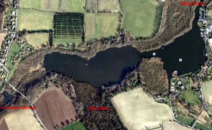
Unlike many other 'side-valley' broads, the waters of South Walsham Broad are confined by the slopes of a valley which are clearly visible. At the east end of the 'outer' broad, a promontory of solid upland separates it from the Upton marshes; from the north you can look down onto the inner and outer parts of the broad from a height of thirty feet or more; brick-built houses line the southern bank of the outer broad, and the gardens of Fairfield House slope downwards to the inner.
It is only to the west, towards the head of the valley, that the tributary stream flows through an area of fen apparently untapped for peat, apart from the small Sotshole or Ranworth Little Broad.
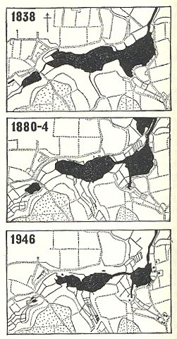
"Like Ranworth Broad, the South Walsham basin once held a continuous sheet of open water, which has been divided up by vegetational overgrowth during the last century into an inner and outer broad, connected only by a narrow channel."
Lambert, Jennings and Smith, 1965
Smith, the historical geographer, found an accurate map from a much earlier date.
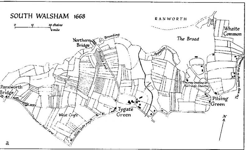
Note This map suggests that the tributary stream, running out through the north-east corner of the broad to join the old course of the river Bure, had in 1668 yet to be formed into part of the navigable Fleet Dyke connecting the broad to the river, although the presence of "Harrold's Staithe" near the village of Pilsing Green suggests the opposite.
"Such historical evidence as there is tends to confirm the idea . . . . that the broads have had a remarkably stable outline until very recent times, when many of the broads have been rapidly diminishing in size." Smith, 1960
The cartographical evidence strongly suggests that, when this basin was originally created, all the peat had been extracted right up to the surrounding slopes of the valley to the north, east and south. The western limit of the broad conforms precisely to the line of the boundary between the parishes of Panxworth to the west and South Walsham to the east; the undug area of fen did not belong to South Walsham. The boundary between the parishes of Ranworth to the north and South Walsham to the south, probably following the original course of the tributary stream as it ran through this side valley, divides the broad in half.
Where, then, are the substantial reserves of peat which the manor was prevented from exploiting in the thirteenth and fourteenth centuries by progressive flooding?
- There are none.
" . . . ., the number of turves sold from the manor alone at South Walsham towards the end of the thirteenth century would have exhausted an acre of turf to a depth of 10ft. in 8 or 9 years." ibid.
We do not know the total acreage of the manor's demesne turbaries, nor what proportion of the whole they represented. We do know that the South Walsham basin originally covered some 70 acres. If all production ended around 1400 AD, and it took three hundred years to dig it out to a depth of 10ft., one acre must have been exhausted every four and a half years. Using Smith's own formula, total annual production by all owners, lessees and tenants would have averaged c 375,000 turves.
There is no evidence of any significant output from the manor's demesne turbaries in the 14th century, so this strongly suggests that the manor's sales of turf before 1268, when the surviving records start, had been at a comparably high level for some time.
In 1315 the manor's turbaries were "worth only 20s. a year.".
- Why? Because there was very little peat left in them!
A DIFFERENT VIEW OF THE EVIDENCE
The peat business was a major source of revenue for many years at South Walsham Manor. However, towards the end of the third quarter of the thirteenth century, it became clear that depletion of their finite turbary resources was at an unsustainable rate. If it continued unchecked, they would find themselves in the position in the foreseeable future not only of having no peat to sell, but of having to buy peat for their own use.
- Accordingly, production of turves for sale was gradually phased out to allow an orderly switch to other sources of revenue. What little peat remained in the demesne turbaries was conserved for the manor's own hearths.
back to: "The Historical Evidence in Detail" HOME
The Origin of the Norfolk Broads - a classic case of Confirmation Bias
mallards